
OUR PROJECTS
Our client portfolio spans a wide range of industries, validating our ability to adapt and deliver comprehensive results to clients from various sectors. We have successfully partnered with organizations of all sizes to achieve their unique goals.
Recent Projects
Topographical surveying for Master plan of the Great Lakes University of Kisumu, Kenya.
Mapping for the Feasibility Assessment and City-Wide Inclusive Sanitation Plan for Nampula City in Mozambique.
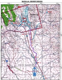
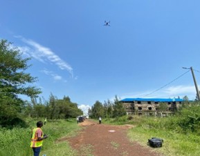
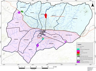
Detailed Topographical surveying for the design of Maralal Town Sewerage System.
Other Projects
| Project Title | Country | Year |
|---|---|---|
| Detailed Topographical Surveying and Mapping for the Master plan design of Great Lakes University of Kisumu. |  Kenya Kenya |
2025 |
| Mapping for the Feasibility Assessment and City-Wide Inclusive Sanitation Plan for Nampula City. |  Mozambique Mozambique |
2025 |
| Detailed Topographical surveying for the design of Maralal Town Sewerage System. | Kenya |
2025 |
| Surveying & mapping for Water Resources and Wastewater Master plan in Kisumu County under LVWATSAN Program. | Kenya |
2024 |
| Cadastral Surveying for Excision of land for Standard Gauge Railway Station from LR No. 1956/506 located in Voi, Taita Taveta county. | Kenya |
2024 |
| Surveying for Creation Of 1/1000 Digital Current Condition Map for Farm Land Consolidation Planning for Mwea Irrigation Scheme. | Kenya |
2023 |
| Surveying for detailed Design of the Tertiary and Feeder Canals for Lower Nzoia Irrigation Scheme. | Kenya |
2023 |
| Surveying and Mapping for the Detailed design of Kismayo Water Reticulation network. |  Somalia Somalia |
2023 |
| Subdivision and processing titles of L. R. Nos 14772/4-14 and 14771/3. | Kenya |
2023 |
| Detailed topographical Surveying for Feasibility Study and Detailed Design of Water Supply and Sanitation System for the Greater Gomba Project Area (Lot 1). |  Uganda Uganda |
2022 |
| Surveying for the Resettlement Action Plan & Land Acquisition for Lower Nzoia Irrigation Project. | Kenya |
2021 |
| Detailed surveying for design and setting out of the Main canal and Secondary canals for the Nzoia Irrigation Project and Improvement of Flood Mitigation Structures. | Kenya |
2021 |
| Detailed Surveying for design of Water Supply & Sanitation System for Kitu Town and environs. | Kenya |
2021 |
| Surveying & mapping for Water Resources and Wastewater Master plan in Kisumu County under LVWATSAN Program. | Kenya |
2020 |
| Cadastral surveying for the design of Lower Nzoia Irrigation Project and Improvement of Flood Mitigation Structures. | Kenya |
2019 |
| Surveying for the construction & supervision of Mbale- Wetsimbalo- Munoywa Road. | Kenya |
2019 |
| Cadastral Surveying for the Kilgoris – Kehancha line High Voltage Transmission Line. | Kenya |
2018 |
| Survey for the infrastructural design of Informal settlements in Nairobi & Kilifi Counties. | Kenya |
2017 |
| Detailed topographical Surveying for the Design of Border Markets and infrastructure for Rwanda, Burundi and DRC Congo. |
 Rwanda, Rwanda,
 Burundi, Burundi,
 DRC DRC
|
2016 |
| GIS and database creation on Protection of Lake Victoria from Urban Waste Discharge Homa Bay & Satellites, Migori – Feasibility and Preliminary Design. | Kenya |
2016 |
| Topographical and Detailed survey for Design, preparation of Bid documents and Construction Supervision of Export Processing Zone Authority Waste Water Treatment plant. | Kenya |
2016 |
| Surveying for the Rehabilitation & Augmentation of Chesikaki- Cheptais- Sirisia water supply network ( 35km of pipeline route). | Kenya |
2016 |
| Surveying for the Design & Construction of water Muruny (Siyoi) dam & Kapenguria water supply project lot 2. ( 180 km of pipe line routes). | Kenya |
2015 |
| Detailed Topographical survey for the Design & Construction of Border posts and border links roads. |
Mozambique,
 Malawi, Malawi,
 Zambia Zambia
|
2015 |
| Detailed Survey for the Design, Preparation of Tender Documents & Construction of Kisumu Urban roads ( 40 km). | Kenya |
2014-2015 |
| Mapping of Gorge farm (800 hectares) and Manera farm ( 700 hectares). | Kenya |
2013 |
| Kenya Informal Settlements Improvements Program. ( Mapping of informal settlements in 10 Municipalities). | Kenya |
2013-2014 |
| Surveying of Bridge sites and approach roads for Malindi-Mombasa-Lunga Lunga Road & Malindi by-pass. | Kenya |
2013-2014 |
| Detail Engineering Design Review for the Tanga Bypass. |  Tanzania Tanzania |
2013 |
| Surveying, GIS & Mapping Training for the ministry of Physical infrastructure staff in Northern Bahr el ghazal state. |  South Sudan South Sudan |
2012 |
| Geodetic Control Survey for Chebilat-Chebera (C22) road. | Kenya |
2012 |